Enregistrez gratuitement cette image
en 800 pixels pour usage maquette
(click droit, Enregistrer l'image sous...)
|
|
Réf : T02980
Thème :
Terre vue de l'espace - Déserts - Dunes (200 images)
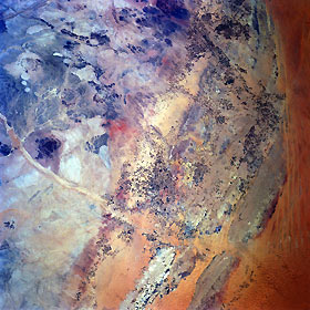
Titre : Desert Farming (Center Pivot Irrigation), Saudi Arabia May 1997
Description : (La description de cette image n'existe qu'en anglais)
The desert landscape of north central Saudi Arabia has a variety of interesting colors and patterns that decrease in elevation across the image from southwest (left) to northeast (right). Darker colored areas tend to be isolated mountains and rocky ridges, while the lighter colored landscapes are sand dunes, areas of sand and gravel, and rock outcrops. Hundreds of cultivated circular fields (look like tiny dark specks on this synoptic view) are scattered between the rugged uplands (left) and red sands of the Nafud Al Mazhur (sand sea) along the right edge of the image. Most of the irrigated fields (referred to as center pivot irrigation) produce cereal grains, mainly wheat. The average field diameter is one kilometer. Many of these fields that are being used for agriculture are located on ancient alluvial fan deposits. Rumah Wadi (light colored, linear feature) extends from the upper left center of the image towards the bottom center. This dry riverbed (watercourse) passes just to the south of Buraydah (below and right of center).
|
|

